
Official base geodata in Germany: which licence applies where?

Germany’s federal states now publish their official base geodata almost everywhere free of charge — parcel boundaries, building footprints, elevation models, aerial imagery. But “free of charge” is not “without conditions”. Each state applies a different licence, and each licence demands a different attribution. Anyone putting that data into a published drawing should know which.
At a glance
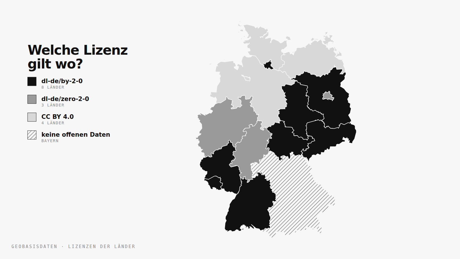
- Three licences cover practically everything: dl-de/by-2-0, dl-de/zero-2-0 and CC BY 4.0.
- zero requires nothing. by and CC BY require attribution in a prescribed form.
- The attribution belongs with the data — on the drawing, in the legend, in the figure credit. Not in the site’s imprint.
- Bavaria is the exception: its parcel geometries are not available as open data.
What base geodata is — and isn’t
Base geodata (Geobasisdaten) is the official groundwork: state surveying and the land cadastre. That includes parcels and boundaries, building footprints, the elevation model, administrative boundaries, topographic maps and aerial imagery. It describes the surface of the earth without interpreting it.
Distinct from that is thematic geodata (Geofachdaten): development plans, protected areas, noise maps, land value indices. These sit with the responsible specialist authorities, follow their own rules and are less often open. And finally there is community data — OpenStreetMap above all — which is not official but works the same way everywhere.
The three licences
dl-de/zero-2-0 — Data Licence Germany Zero
The most permissive variant. The data may be copied, modified, used commercially and redistributed without any required attribution. For a drawing headed to print, that is the least complicated basis. Crediting the source anyway never hurts — it makes the provenance of a geometry traceable.
dl-de/by-2-0 — Data Licence Germany Attribution
Same freedoms, but attribution is mandatory — in exactly the form the data provider specifies, including a year where one is required. Writing “Source: state survey office” where “© GeoBasis-DE/LVermGeoRP (2026), dl-de/by-2-0, www.lvermgeo.rlp.de” is demanded does not satisfy the licence.
CC BY 4.0 — Creative Commons Attribution
Internationally familiar and close in substance to dl-de/by. It requires attribution, a licence notice and an indication if the material was modified. That last point is the one most often missed: deriving contour lines from an elevation model is a modification.
Which state requires what
The attributions below are the ones we carry for each state’s parcel data in our cadastral map. They come from the terms of use of the respective state services and are shown alongside every parcel. They are reproduced here in the original German, because that is the form the licences require.
| State | Licence | Required attribution |
|---|---|---|
| Baden-Württemberg | dl-de/by-2-0 | © LGL-BW (2026), dl-de/by-2-0, www.lgl-bw.de |
| Bavaria | — | Parcel geometries not available as open data |
| Berlin | dl-de/zero-2-0 | © Geoportal Berlin (dl-de/zero-2-0) |
| Brandenburg | dl-de/by-2-0 | © GeoBasis-DE/LGB, dl-de/by-2-0 |
| Bremen | CC BY 4.0 | © Landesamt GeoInformation Bremen (CC BY 4.0) |
| Hamburg | dl-de/by-2-0 | © Freie und Hansestadt Hamburg, Landesbetrieb Geoinformation und Vermessung, dl-de/by-2-0 |
| Hesse | dl-de/zero-2-0 | © Hessische Verwaltung für Bodenmanagement und Geoinformation (dl-de/zero-2-0) |
| Mecklenburg-Vorpommern | CC BY 4.0 | © GeoBasis-DE/M-V (2026), CC BY 4.0 |
| Lower Saxony | CC BY 4.0 | © LGLN (2026), CC BY 4.0 |
| North Rhine-Westphalia | dl-de/zero-2-0 | © Geobasis NRW (dl-de/zero-2-0) |
| Rhineland-Palatinate | dl-de/by-2-0 | © GeoBasis-DE/LVermGeoRP (2026), dl-de/by-2-0, www.lvermgeo.rlp.de |
| Saarland | dl-de/by-2-0 | © LVGL 2026, dl-de/by-2-0, www.lvgl.saarland.de |
| Saxony | dl-de/by-2-0 | © Geodaten Sachsen, dl-de/by-2-0 |
| Saxony-Anhalt | dl-de/by-2-0 | © GeoBasis-DE/LVermGeo ST, dl-de/by-2-0 |
| Schleswig-Holstein | CC BY 4.0 | © GeoBasis-DE/LVermGeo SH/CC BY 4.0 |
| Thuringia | dl-de/by-2-0 | © GDI-Th, dl-de/by-2-0 |
The year in some attributions refers to the year the data was obtained, not the current year. Using data from 2024 means writing 2024.
The gap: Bavaria
Bavaria is opening its base geodata step by step, but parcel geometries are not yet part of that. The state therefore appears without boundaries on our cadastral map — not because we skipped it, but because there is no open service to draw the geometries from. Looking up a parcel there still means going through BayernAtlas or the responsible state office.
Where the attribution belongs
Both attribution licences want the notice with the data. In practice:
- On the drawing — in the legend or as a footer along the sheet edge, like a scale bar.
- In the publication — in the figure credit, not in the website imprint.
- In the file — in the metadata of a GeoJSON or shapefile, or in an accompanying text file.
The imprint is the wrong place: anyone who passes the figure on does not pass the imprint on with it.
Frequently asked
May I use the data commercially?
Yes — all three licences permit commercial use explicitly. Under dl-de/by-2-0 and CC BY 4.0 the attribution has to travel with it.
Does attribution apply to derived drawings too?
Yes. A figure-ground plan built from official building footprints is a derivative. CC BY 4.0 additionally requires an indication that the material was modified.
What about OpenStreetMap?
OSM is published under the ODbL. Beyond attribution, it requires derived databases to be shared under the same licence. That does not bite for a rendered figure, but it does for a redistributed dataset — the substantive difference from the German data licences.
Do the licences change?
Yes, generally towards more openness. Several states have moved from paid access to dl-de/by and on to dl-de/zero in recent years. What governs is the condition in force when the data was obtained.
If it needs to be quicker
Sixteen portals, three licences and one state without open data is manageable for a single project and much less so for the tenth competition of the year. Our free outlines cover cities, countries and continents, and the finished figure-ground and site plans deliver the built context as PDF, DXF and DWG — separated layers, licensing settled.
Access All Plans
Every plan. One pass.
A full year of access to the entire archive — every city, every format, every layer, commercial licence included.
View Access All Plans 99 €How to look up a single parcel is covered in finding a parcel and reading the cadastral map.